


The Rubicon Trail combines granite slabs, technical rock crawling, mountain lakes and remote camping in California’s High Sierra west of Lake Tahoe. For UTV riders, it is a place to test tire placement, ground clearance and patience while enjoying some of the Sierra’s best backcountry scenery.
UTV Guide has explored the Rubicon in everything from early side-by-sides to modern sport and utility UTVs. This guide covers the main entrances, staging, camping and named obstacles, with photos and videos from our rides.
Where Is the Rubicon Trail?
The Rubicon crosses El Dorado and Placer counties near Lake Tahoe. It follows a county road/right-of-way through public and private land. The broader route is often described as approximately 22 miles, while the popular Loon Lake-to-Tahoe trip covers roughly 12 miles of off-road terrain. Your actual distance depends on the entrance, exit and side trips you choose.
Many groups travel west to east, entering at Loon Lake or Wentworth Springs and exiting near Tahoma. Traffic travels both directions, so expect to meet other vehicles in narrow sections. A through-trip requires a trailer shuttle or another return plan; reaching the Tahoe end does not put you back at your starting point.
Rubicon Trailheads and Staging
- Loon Lake: The popular western entrance starts at the spillway and crosses the Granite Bowl. Loon Lake trailhead map.
- Wentworth Springs: The historic western approach is reached through the Airport Flat area and joins the Loon Lake route near Ellis Creek. Airport Flat area map.
- Tahoma/Lake Tahoe: The eastern approach follows the McKinney–Rubicon Springs road network from Highway 89. Follow signed directions to the trail staging area. Tahoe-side staging map.
The Loon Lake spillway area is a common place to stage trucks and trailers. Check posted parking instructions, leave room for other trailers and keep emergency access clear. Confirm current parking arrangements near the chalet before using that area, and keep the helicopter landing area unobstructed.
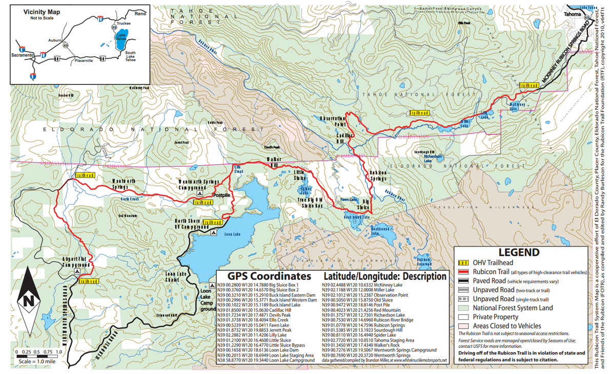
Download the current El Dorado County Rubicon Trail map before leaving service. The county also provides an Avenza map option. The map above is retained from our original guide.
How Difficult Is the Rubicon in a UTV?
The Rubicon is a technical rock-crawling route with repeated ledges, loose rocks, off-camber sections and tight turns. A capable UTV can make some obstacles feel easier than they do in a full-size 4×4, but line choice still matters. Vehicle width, wheelbase, tire size, gearing and driver experience all affect the trip.
For a first visit, travel with someone who knows the route and leave time for spotting, traffic and repairs. A short out-and-back from Loon Lake can introduce the terrain without committing to a complete crossing. An overnight trip allows more time to enjoy the lakes and campsites.
Where to Camp on the Rubicon Trail
For a base camp near the western entrances, look into Northshore and other Loon Lake camping options, Airport Flat and Wentworth Springs. Check current opening dates, fees and reservation arrangements before traveling. Confirm which access roads allow your OHV rather than assuming every paved road between camp and the trailhead is open to it.
Along the trail, Ellis Creek and Buck Island Reservoir are familiar camping areas. Use established sites where camping is permitted, respect property boundaries and keep vehicles on authorized routes. Carry a human-waste pack-out system even when you expect toilets to be available.


Rubicon Springs is private property. It is a popular overnight stop along the Rubicon River, but camping fees, availability and event access should be confirmed with the property operator. See the Rubicon Trail Foundation camping guide for locations and the Rubicon Springs contact link.


Rubicon Trail Obstacles
Obstacles change with weather, erosion, trail work and vehicle traffic. The videos below show our rides at the time they were filmed; inspect the current line before attempting it.
Granite Bowl
Entering from Loon Lake puts you onto broad granite slabs. Follow route markers across the rock rather than treating the open granite as permission to drive anywhere.
Walker Hill
Walker Hill adds a rocky climb to the western approach. Choose a controlled line and leave space between vehicles so a stopped rig does not force the next driver into a rushed decision.
Soup Bowl
Soup Bowl offers an optional technical challenge. The video shows Phil Blurton tackling it in a Can-Am Maverick X3 X RC. Evaluate your vehicle and experience before committing to the line.
Little Sluice
Little Sluice is one of the Rubicon’s best-known rocky sections. Assess the current terrain and use a spotter when tire placement is difficult to see from the cab.
Old Sluice
Old Sluice is an alternate technical route in the Buck Island area. Confirm the junction on your map and evaluate the descent or climb before choosing it.

Big Sluice
Big Sluice combines rocks and tight maneuvering on the route toward Rubicon Springs. Keep your pace controlled and plan turns around the vehicle’s wheelbase.
Cadillac Hill
For a west-to-east crossing, Cadillac Hill is the climb beyond Rubicon Springs toward the Tahoe side. Include this section in your time, fuel and recovery planning.
Preparing Your UTV for the Rubicon
- Inspect the vehicle: Check steering, suspension hardware, brakes, wheel bearings, tires, fluids and the drivetrain. Repair leaks before leaving.
- Protect the underside: Inspect skid plates and vulnerable suspension or driveline components before repeated contact with granite.
- Choose tires carefully: Traction, sidewall durability and clearance matter. Larger tires can also affect gearing and driveline loads. See our 35-inch sticky UTV tire guide.
- Bring recovery and repair gear: Carry appropriate recovery equipment, tools, tire repair supplies, an air source and vehicle-specific spares. CVT-equipped machines should carry a spare belt and the tools to install it.
- Plan for an extended stop: Bring drinking water, food, warm layers, first-aid supplies, offline maps and emergency communications. Secure your cargo and share your route and return plan with someone at home.
See what we learned in our Maverick X3 X RC Rubicon review, Yamaha Wolverine X2 rock-crawling review and Can-Am Commander Rubicon test.
Current Conditions and Responsible Riding
Snow, runoff, wildfire, smoke and storms can affect the trail and approach roads. Check El Dorado County’s Rubicon Trail updates and the Rubicon Trail Foundation conditions page before traveling. Check event schedules as well, particularly when planning to camp at Rubicon Springs.
Follow current fire orders and obtain any required campfire permit. A permit does not override fire restrictions. The county’s Rubicon page also links to California State Parks information on OHV registration and visiting from out of state.
Protect the trail by staying on designated routes, avoiding vegetation and meadows, crossing streams only at designated points and carrying a spill kit. Pack out trash and human waste where toilets are unavailable; never put waste bags into vault toilets. Read the county’s sanitation, spills, sedimentation and safety guidance.
More Rubicon Trail Videos and Trip Reports
For more from our rides, read Camping Trip on the Rubicon Trail, our 2007 Rubicon Trail UTV run and the 2011 Kawasaki Teryx Rubicon adventure.


